Title /
Abstract /
Contents /
Part 1 /
Part 2 /
Part 3 /
Prev./
Next
Dead Reckoning Equipment
Dead Reckoning requires the measurement of displacement and direction traveled. It also requires a way of recording this information and applying it to the navigation model.
An odometer is the simplest and most direct method of measuring distance traveled on the lunar surface. This may be accomplished electronically by fastening a magnet to the rotating wheel or axle, and placing a magnetically actuated switch on a non rotating part of the vehicle such that each rotation of the wheel will result in the actuation of the switch. Each rotation is added to a running sum and the result is multiplied by the circumference of the wheel to arrive at distance traveled. Another option may be an optical sensing system, such as a bar code reader which continually scans the perimeter of the wheel hub or axle.
On Earth, measurement of heading is usually performed by magnetic compass. Since the lunar magnetic field is weak and largely uncharted, direction must be determined by other means. Several options are available. Gyroscopic compasses; sometimes known as gyrocompasses, or directional gyros; are one such option. They operate on the principle of rotational inertia, maintaining a fixed reference for measurement of direction or rotation. A complete examination of the principles of the directional gyro would fill volumes and is well beyond the scope of this project. Bowditch, chapter VI, has an excellent reference on gyrocompasses used in navigation. For conceptual purposes, a generic directional gyro consists of a spinning mass in a two-degree-of-freedom gimbal system, depicted in Figure 6. Understand also that, for various reasons, gyroscopes drift or precess, and thus require periodic resetting to eliminate errors in directional reference.
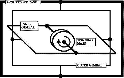
Figure 6. Two degree of freedom gyroscope
Current and near future equipment could employ ring laser gyros or other solid-state heading references. Another reference could be a celestial tracking device which senses the direction of the sun or other celestial bodies, and, in conjunction with ephermeris data, generates azimuth information [Hung, 1971]. Combinations of any or all of these more advanced devices could be used. For conceptual purposes, consider the directional gyro as a generic device used for azimuth determination. This azimuth could be the vehicle heading used for dead reckoning, the azimuth to a distant mountain peak for purposes of obtaining a fix, or some other directional information.
Measurements of direction and distance must be accumulated and processed to yield the vehicle's present position. This task is best accomplished by a digital computer utilizing a dead reckoning algorithm. The following equations would form the basis of an algorithm for the low-fidelity navigation model:
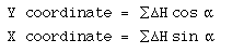
Where a (alpha) is the vehicle's heading angle as measured by the directional gyro, and H is the horizontal distance traveled as measured by the odometer system.
Periodic fixes and heading updates must also be applied to the system, and the computer program must support these activities. Experimental software has been developed for the specific task of landmark fixing on the moon, and could be adapted to the low-fidelity model [Lewis, 1970-1]. Other software considerations would be the user interface; what specific information must be generated by the system, and how the information would be presented to the user.
Prev./
Next