Title /
Abstract /
Contents /
Part 1 /
Part 2 /
Part 3 /
Prev./
Next
As in the low-fidelity dead-reckoning system, the high-fidelity system will experience error, and the position generated by the INS will wander, requiring a fixing scheme to restore the fidelity of the navigation model. A celestial fixing scheme was selected due to the global availability of celestial objects and the compatibility of celestial navigation with the high-fidelity navigation model.
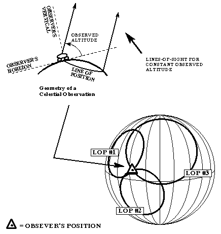
Celestial navigation involves measuring the altitude above the horizon of a celestial body and resolving this information into a line of position (LOP). The LOP is a locus of points along which the observer must be if he is observing a celestial body at a specific angle above the horizon, Ho ("height observed") as shown in Figure 11. For the lunar navigator, this locus of points is a circle on the surface of the model lunar sphere centered on the subpoint of the body being observed. The subpoint of a celestial body is that point on the surface of the model sphere such that the celestial body is at the zenith. Two observations will establish two LOPs which will intersect at two points. The navigator, human or machine, may then compare both of these intersections to the dead-reckoning position in order to decide which represents the actual position. Three or more celestial observations will yield three intersecting LOPs and constitute an unambiguous fix. This process may be performed mathematically, yielding the navigator's latitude and longitude [Bowditch, 1984].

Figure 11: A celestial fix using 3 lines of position (LOPs)
In practical navigation, celestial altitude is often measured not by observing the angle between the horizon and the body, but by referencing an "artificial horizon" to local vertical. Determining local vertical can be easily accomplished by referencing the local gravity vector with a vertical sensing device; whereas determining the horizon is only possible when surrounded by perfectly smooth, flat, level terrain. Air navigators conducting celestial observations use a sextant equipped with a spirit level to reference local vertical. A lunar navigator could utilize the same basic system, or vertical sensing may be accomplished automatically with a pendulum device.
Since automation of navigation tasks is desirable in order to reduce errors and save valuable time, celestial observations may be best made by an imaging system capable of sensing and identifying navigational stars as well as the Earth and Sun. Image analysis software is being developed for star identification tasks, and is discussed in section 3. In any case, it should be possible to reduce the astronaut's involvement in the celestial fixing process to occasional monitoring or confirmation that the navigation system has selected the correct stars. From there, the system could measure the body's altitude and perform all the necessary navigation calculations automatically.

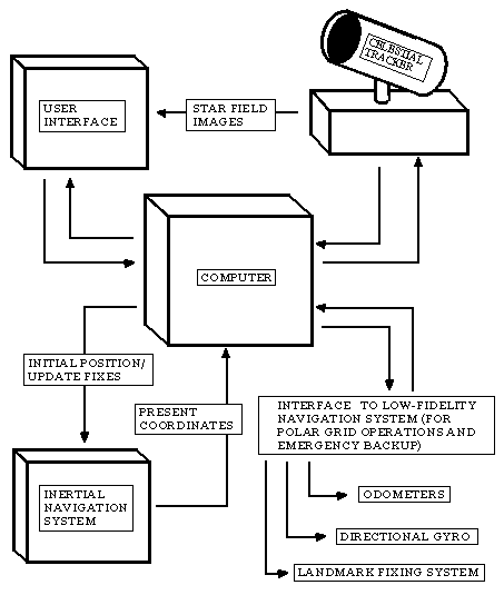
Figure 12: Schematic of high-fidelity system
Typical System Operation
After power is applied, the system must be provided with current position and a directional reference. For user convenience and flexibility, the system should be able to accept an initial position entered as lunar latitude/longitude, or as determined by a celestial fix. Heading may be initialized by celestial means as in the low-fidelity system.
Enroute navigation will be performed by the Inertial Navigation System. As time passes, position errors will accumulate due to equipment inaccuracies, and the heading reference will wander. Periodic celestial fixes will be necessary to restore the system to a correct position and heading reference. Fixing and realignment would best be performed while the vehicle is stationary in order to minimize vibration and other movement affecting accuracy.
Advantages and Disadvantages
The primary advantage of this system is it's ability to navigate over long ranges accurately. Celestial fixing can be performed anywhere on the Moon, so no salient landmarks are required. With appropriate software, the system could function almost automatically, with only minimal intervention by an astronaut. Its basic components; an INS, a celestial sensor, and a computer; are already in existence, so development would only require adapting existing technology to the mission at hand.
Unfortunately, the system would be more complex and expensive than the low-fidelity navigation system. It would be more subject to failure, and likely be heavier as well. And strangely enough, the low-fidelity navigation scheme could prove more useful for navigating in high polar latitudes than the high-fidelity scheme, as will be discussed in a few pages.
Possible Improvements
Correcting these deficiencies may be as simple as combining the low-fidelity navigation system with the high-fidelity system. both systems would be able to compare information, including inputs both from odometers and from accelerometers, INS and directional gyro heading references, and celestial and landmark fix information. At the same time, both systems could operate independently; if one system fails, the other is available as a backup.
Prev./
Next